
Walking round London pt10: North Woolwich Pier to Maryon Park
Over (well, under) the river as the second quarter of the 120km capital circumnavigation continues
(ICYMI: on Sat 5 May, the writer walked 36km as the first quarter of a 120km circumnavigation of the capital for charity; on Sat 26 May, he walked the next quarter. These blogs are to publicise the fundraising and consider the vernacular. There’s a full list of chapter/sections at the end of each blog.)
As we near the modern iteration of the Woolwich Ferry, I’m pleased to notice its name Ernest Bevin is in London transport’s (literally) trademarked font, Johnston: the “i” is topped with the familiar diamond-shaped dot — a tell-tale tittle. But then, this is a truly integrated part of the capital’s transport system. Every year, around 2.5m people and one million vehicles use the free ferry, which joins the North Circular to the South Circular to complete the circuit of London’s original, interwar ring road.

Tittle tease
Some of the latest additions to the traffic numbers are queuing for the incoming Ernest, and we nip between them as we turn away from the river toward Pier Road. Across it, proudly fronting what is now wasteland, is an intriguing entrance to nowhere, marked with the date 1937. This, it transpires, was an electricity transformer station for the pierhead, and originally bore a plaque with the Woolwich coat of arms — three cannon barrels each bearing the head of a leopard or lion, with the legend clamant nostra tela in regis querela: “Our weapons clash in the King’s quarrel”.
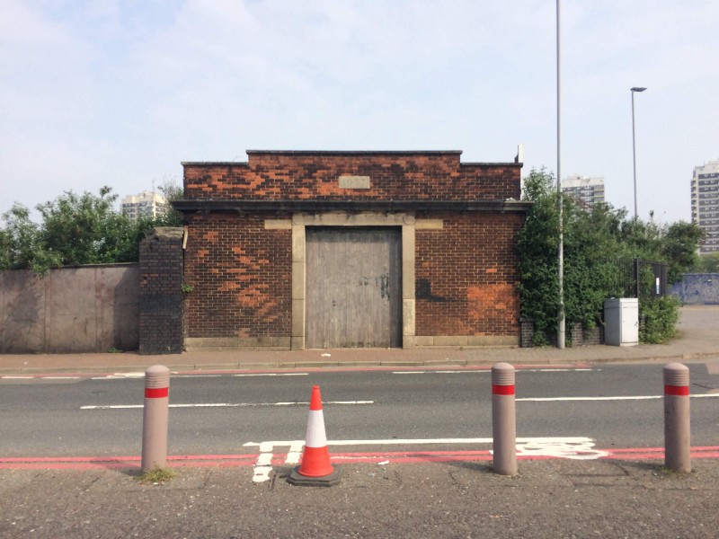
Just a substation, really. But, someone thought, why not make it well?
The observant may have picked up that Woolwich is south of the river and we’re still on the other side, but this area — still known as North Woolwich — was part of Kent from the time of the Domesday Book. There have been connections across the river for millennia, and we’re about to use one of the latest.
Like its upstream sibling at Greenwich, the Woolwich Foot Tunnel was brought to fruition by Will Crooks. This third son of a ship’s stoker and a seamstress experienced the workhouse after his father lost his arm in an accident; reading up on Cobden and Bright, he spoke in favour of striking dockers and became an agitating politician — London County Council member, then the first Labour mayor of Poplar, then from 1903 he represented Woolwich as Labour’s fourth-ever MP.
A former docker, Crooks recognised the value to workers of a foot tunnel and the LCC agreed; designed by their Chief Engineer, the marvellously-named Maurice Fitzmaurice — who was also responsible for the Rotherhithe Tunnel and Vauxhall Bridge and retired, presumably knackered, shortly afterwards — the Woolwich Tunnel opened in 1912.

How to make an entrance.
Each entrance, grade II-listed, is a red-brick rotunda topped with copper dome and a conical roof lantern, then it’s down a 126-step spiral staircase into the surprisingly deep, pleasingly cool 500m-long tunnel.

If I’m honest, this bit smelt of wee.
Although straight as an arrow, it inclines upwards to the south exit, where there’s just the 101 steps — eschewing the lift option was a mater of principle which would bite me in the legs later — and suddenly I had become one of the 1.5m people per year to use this 24-hour public highway.

While the northern entrance stands proud, the south entrance (or, I suppose, exit) is overshadowed by the Waterfront leisure centre, a regrettable steel-and-glass affair that Greenwich Council intend to demolish and relocate elsewhere, opening the view to the tunnel (and the land for lucrative housing development). It takes me a confusing few seconds to pick up the trail again — helped by the first batch of pink-shirted charity helpers and well-wishers — and we’re back along the riverside trail, heading upstream.

Westward past the unused ferries. Barrier ahead, Tate & Lyle over the river.
Behind the pair of tethered ferries bobbing about on their day off I can see the Thames Barrier, loomed over by the Tate & Lyle factory which dominates the dockland skyline. The path now crosses the entrance to a couple of former docks around which various ages of housing have been thrown — 60s, 80s, noughties and presumably the bits in between. At the southern end of King Henry’s Dock, slated (as most things are) for redevelopment, a thirtysomething bloke stands and gazes at the water with the sort of patience associated with fishermen, except there’s no rod or tackle.

King Henry’s Dock used to be of vital national importance.
Although named after the bloke with the big appetite for wives, wine and wars, who founded the Woolwich Dockyard back in 1512, the present King Henry’s Dock was built in the 1840s; at that point, decommissioned naval vessels were moored offshore to house prisoners who would otherwise, until 1776, have been sent west to the US colonies. Such enthusiasm for overseas adventures helped make a name for the parish, especially after the establishment of the Royal Arsenal (from which was named the nascent football team, later controversially resituated in Islington).
The Board of Ordnance first hit the parish in the 1540s, initially storing their shooters then developing the production of gunpowder, cartridges, firearms, fireworks and all manner of other things that go bang. Then came an academy, barracks, wharves, a canal and, as the Napoleonic wars continued, ever more armoury manufacture, when meant the site needed protecting — hence the 1847 creation of a gun battery pointing menacingly out into the Thames.

Cannon to left of them, cannon to right of them, but someone’s nicked the life-ring.
The battery was rebuilt in 1976, while replacement wrought-iron gun carriages for the resited cannon were made in 2005. Behind them, street furniture is quietly being reclaimed by nature. It’s part of a much longer-term cessation of activity: the Royal Military Academy moved to Woolwich Common in 1808, the dockyard closed in 1869, the Royal Ordnance factory made its last bang in 1967, and all military use of the site had ceased by 1994.

Hopping over an unnecessarily complicated white steel bridge which vaults the floodwall at the north-east corner of a late-20th century estate, we get our clearest view yet of the Thames Barrier, designed to protect London from the triple threat: high tides coinciding with a storm surge and heavy fluvial flow from upstream. In recent years it’s more often been the latter that’s the problem: in the floods of 2013–14 the barrier was closed 41 times to hold back the incoming tide so the river could drain more quickly.

I could have done without the steps, thanks.
In time it’s hoped that the Capital Ring path will continue westwards along the river — perhaps as far as the Barrier — before diving south towards Maryon Park. As it is, the way is barred by a light-industrial unit which has callously thrown up a 10-foot concrete wall obscuring the dear old Thames: those who park their cars against it may not even know there’s a river there until they climb out and smell the salt. So the path dips through the housing estate that now covers the old arsenal and dockyard.

Note the pink arrow. Always note the pink arrow.
Harlinger Street and Ruston Road now occupy land that in the 19th century broiled with an engine-house, a foundry, rolling mills, a boiler factory and a dry dock (infilled around 1960) wherein the Admiralty was allowing the fitting of these newfangled steamships. The major visible remnant is the octagonal chimney, formerly 208ft but now nearer 180ft, which vented all the yard’s flues.

As Ruston Road curls toward the south-west corner of the former site I pass a McDonalds. A toddler thinks it’s fun to outpace his sizeable mother in the car park, but recognises the difference between anger and fear in her shrieks as he barrels straight onto the (thankfully empty) road. Woolwich was the site of the UK’s first McDonald’s, in 1975; it replaced a branch of Burton’s the tailors.
This is a drive-through by a roundabout, over which looms a corner-pub ghost. Despite the bold proclamations on the blackboard, I doubt it has karaoke every Sunday these days. It might have in the future — it’s being done up — but I doubt it did when it was The Lord Howick, aristocratically lounging over what used to be Trinity Street. It was later renamed Million O’Hare (karaoke: strong possibility) and finally Clancy’s (karaoke: near-certainty) before it closed in 2015.

The former Lord Howick on the former Trinity Street; now being restored on Warspite Road.
Trinity Street was also renamed, in 1937, becoming Warspite Road. Named for the old battleship used to train boys into seamanship, Warspite Road was the westerly extremity of the dockyard, so we cross the A206 (it’s like the South Circular, but one louder) and head up the first of many inclines.
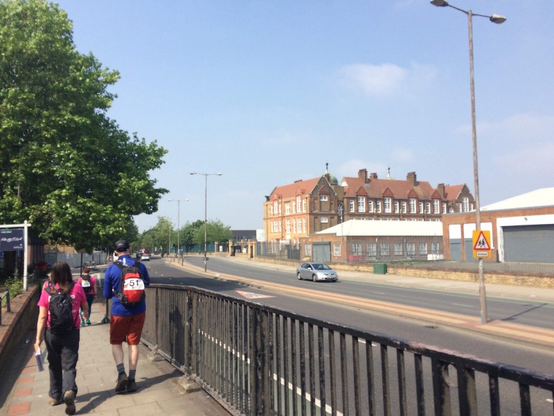
Across the dual carriageway rises an eye-pleaser. The sign above the door reveals it as Maryon Park School, built in 1894–6 by TJ Bailey for the London School Board on the marshy ground of a piggery. It’s been through several educational iterations since: a postwar girls’ secondary with mixed juniors, the an annexe to the Charlton Secondary for Boys, then the upper schools for Charlton, then the (private) Holborn College and most recently part of the split-site Windrush Primary School.
And then, leaving that behind us, after 90 minutes of pounding pavements we enter the cool shade of parkland, where we’ll stay for almost all of the next two hours, give or take a couple of road crossings. The green ways will take me past the sites of a suspected murder, a mimes’ tennis match, polo played on bicycles, a hangman’s gibbet, a triangular castle and “impudent” women of “indecency and immodesty”. But all that’s to come…
Coming up next: Into the (murderous?) glade
The Mencap Capital Challenge is a charity walk circling London in four quarters, each roughly 30km. You can donate or sponsor the writer at justgiving.com/garyparkinson1974. You can also join in: the South quarter (Crystal Palace to Richmond) will take place on Sat 9 June, the West quarter (Richmond to Hendon) on Sat 7 July.
NORTHERN QUARTER, SAT 5 MAY 2018
• Pt1: Wembley to East Finchley • Pt2: …to Finsbury Park
• Pt3: …to Clissold Park • Pt4: …to Springfield Park
• Pt5: …to Hackney Wick • Pt6: …to Bow Back River
• Pt7: …to Channelsea River • Pt8: …to Royal Victoria Dock
EASTERN QUARTER, SAT 26 MAY 2018
• Pt9: Victoria Dock to North Woolwich Pier • Pt10: …to Maryon Park
• Pt11: …to Hornfair Park • Pt12: …to Oxleas Wood
• Pt13: …to Eltham Palace • Pt14: …to Grove Park
• Pt15: …to Beckenham Place Park • Pt16: …to Penge
• Pt17: …to Crystal Palace Park • Pt18: …to Upper Norwood
SOUTHERN QUARTER, SAT 9 JUN 2018
• Pt19: Crystal Palace to Beulah Hill • Pt20: …to Streatham Common
• Pt21: …to Tooting Bec • Pt22: …to Wandsworth Common
• Pt23: …to Wimbledon Park • Pt24: …to Richmond Bridge
WESTERN QUARTER, SAT 7 JUL 2018
• Pt25: Richmond Bridge to Isleworth • Pt26: …to Hanwell Locks
• Pt27: …to Horsenden Hill • Pt28: …to Sudbury Hill
• Pt29: …to Wembley, and that's that


